This guide presents the top three richest states in Igbo land (as listed here) using annual revenue (approx.) as the ranking lens, and then provides a geographer’s interpretation of what those figures mean on the ground—across cities, markets, transport corridors, farmlands, and resource zones.
Before we rank anything, it is important to clarify two ideas that are often mixed together in everyday conversation: “rich” as revenue versus “rich” as lived prosperity. A state can record high annual revenue and still have uneven public services or high unemployment. Another state may have lower official revenue but a powerful informal economy, strong diaspora remittances, or dense trade networks that raise household incomes. So, in this guide, “richest” is treated primarily as a fiscal indicator, while the commentary interprets the wider economic geography that supports (or undermines) those figures.
Igbo land, in the broad cultural-geographic sense, refers to the Igbo-speaking homeland in south-eastern Nigeria and nearby Igbo-populated areas. It is defined not just by administrative boundaries but by language, kinship networks, market linkages, and historical settlement patterns. This is one reason a geographer’s lens is useful: state borders matter, yet economic life frequently spills across those borders—through daily commuting, supply chains, seasonal migration, and inter-city trade.
What makes the Igbo region particularly noteworthy is the scale of commercial urbanism and entrepreneurial networks that link its states to the rest of Nigeria and beyond. The region’s prosperity is shaped by factors such as market centrality (e.g., Onitsha), industrial clustering (e.g., Nnewi and Aba), resource rents (oil and gas in some areas), agricultural productivity, education and human capital, and the geographies of mobility and diaspora remittances. When you see a revenue number, you are seeing the “surface” of many deeper spatial and social processes.
With those ideas established, here is the ranking table of the three states listed in this guide, followed by detailed profiles of each.
| State | Capital City | Annual Revenue (Approx.) |
|---|---|---|
| Anambra | Awka | ₦30.9 billion |
| Abia | Umuahia | ₦21.5 billion |
| Imo | Owerri | ₦18.2 billion |
How to read this table as an expert: “Annual revenue” is a fiscal measure that can reflect internally generated revenue, statutory allocations, and other streams depending on the reporting source used. These figures help compare relative fiscal capacity, but they should be interpreted alongside economic structure, population size, urban density, and the state’s ability to convert revenue into functioning infrastructure and services.

A Geographer’s Method: What Actually Makes a State “Rich” in Igbo Land?
In regional geography, wealth is best understood as a system rather than a single number. In practice, the relative “richness” of a state in Igbo land usually depends on a combination of:
- Urban market centrality: states with major commercial cities can generate revenue through trade volume, transport flows, and service economies.
- Industrial clustering: manufacturing hubs create dense networks of suppliers, logistics, and skilled labor (and therefore taxable activity).
- Transport geography: road corridors, river crossings, and proximity to major national routes influence the movement of goods and people.
- Natural resources: oil and gas can raise revenue quickly, but also introduces governance and volatility challenges.
- Agricultural productivity: fertile lands, water availability, and value chains (cassava, yam, oil palm, rice, etc.) contribute to incomes and trade.
- Human capital: literacy, education institutions, and skilled labor influence enterprise growth and business density.
- Diaspora and remittances: many Igbo communities have strong translocal networks that inject capital into local markets and real estate.
What this means is that a revenue ranking is not “just money.” It is a simplified summary of how a state’s geography enables or limits economic activity. Let’s now explore each of the three states—Anambra, Abia, and Imo—through the lens of landscape, cities, infrastructure, and economic structure.
1. Anambra State
Anambra State, located in south-eastern Nigeria, is often described as one of the richest states in Igbo land. From an economic geography perspective, Anambra’s prosperity is strongly tied to its strategic location, dense urban networks, and high-intensity commerce. It is also a state that illustrates how trade corridors and market centrality can generate both formal and informal wealth.
With over 11 million people (as commonly referenced in some discussions), Anambra is frequently described as one of the most densely populated states in Nigeria—often mentioned alongside Lagos in conversations about density. Regardless of the exact figure used in different sources, the point remains: Anambra has a large, highly urbanized population distribution relative to its land area, which creates powerful consumer markets and labor supply but also increases pressure on housing, transport, and public infrastructure.
The state’s name is associated with the Anambra River, also called Omambala, a tributary of the River Niger. This matters geographically: rivers are not only physical features; they shape settlement, agriculture, trade routes, and cultural identity. Historically, proximity to the Niger and its tributaries helped define trading relationships and movement patterns long before modern highways dominated mobility.
Anambra’s climate is tropical with wet and dry seasons, and average temperatures are warm year-round. Rainfall patterns support agriculture, though rainfall totals and seasonal distribution can vary. Climate matters economically because it influences crop calendars, flooding risk, road conditions, and even the timing of market cycles in rural and peri-urban areas.
Demographically, Anambra is predominantly Igbo, and its cultural landscape is rich in festivals, ceremonies, and community life that reinforce social cohesion. In the Igbo economic system, social ties often function as business infrastructure: apprenticeship systems, kinship-based trade networks, and rotational credit practices can support entrepreneurship even in the absence of easy access to formal banking.
Economically, Anambra is a powerhouse. The state has a booming business sector and a growing industrial base. It is often described as having natural resources such as crude oil, natural gas, bauxite, and ceramic-related materials. However, what is most visible in everyday economic life is not resource extraction alone—it is the state’s role as a commercial gateway between the south-east and broader Nigerian markets.
Most of Anambra’s land is productive, supporting agriculture as a key part of the economy. Yet the state’s major cities—Onitsha, Nnewi, and Awka—are the anchors that make Anambra exceptional:
Onitsha: Port-City Legacy, Market Power, and Corridor Advantage
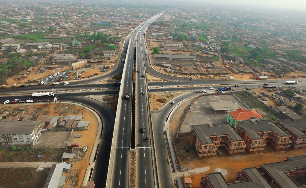
Onitsha is a historic Niger River city and one of Nigeria’s most commercially significant urban centres. Its market reputation is continental: it hosts one of Africa’s largest markets, attracting traders from across Nigeria and neighboring countries. The geographical logic here is straightforward: Onitsha sits near major transport crossings and road corridors. Goods moving between the south-east, south-south, and the north often pass through or near Onitsha. When a city sits on a movement corridor, commerce concentrates there—warehouses, logistics services, retail clusters, transport unions, and financial services follow.
Market cities like Onitsha generate revenue not only through direct taxation (where effectively captured) but also through secondary economic effects: commercial real estate demand, transport service markets, and dense micro-enterprise growth. In practical terms, “richness” in Anambra is shaped by how such cities intensify economic activity per square kilometre.
Nnewi: Industrial Cluster and the “Japan of Africa” Narrative
Nnewi is often called the “Japan of Africa,” a nickname that reflects its reputation for manufacturing and enterprise. From a geographer’s lens, Nnewi functions as an industrial cluster—a concentration of related manufacturing activities that benefits from shared suppliers, skilled labor, repair services, and market access. Industries here are associated with automobiles, motorcycles, spare parts, and a range of mechanical and household goods.
Industrial clusters matter because they create economies of scale. When many firms operate in one space, knowledge circulates faster, apprenticeships become pipelines for skills, and suppliers can specialize. This is a major reason Anambra’s economy is resilient: it is not dependent on one sector alone, but combines trade, manufacturing, and services.
Awka: Administrative Capital and Education-Led Growth
Awka, the capital, plays a different role. Administrative capitals often generate growth through public-sector employment, institutional services, and real estate expansion. Education also strengthens Awka’s position. The state is home to institutions such as Nnamdi Azikiwe University (UNIZIK), Anambra State University, and the Federal Polytechnic, Oko. Higher education institutions contribute to local economies by attracting students, creating housing demand, supporting transport services, and generating professional labor pools.
Anambra is often described as having one of the higher literacy rates in Nigeria, with many children enrolled in schools. Human capital is not an abstract concept; it supports enterprise, innovation, and service-sector development. It also influences how communities respond to new economic opportunities, from technology adoption to business formalization.
Finally, Anambra is also improving in infrastructure, healthcare, and security in many areas—factors that affect investment. In geography, investment follows confidence: when roads, safety, and public services improve, private sector activity often expands because risk is reduced and movement becomes easier.
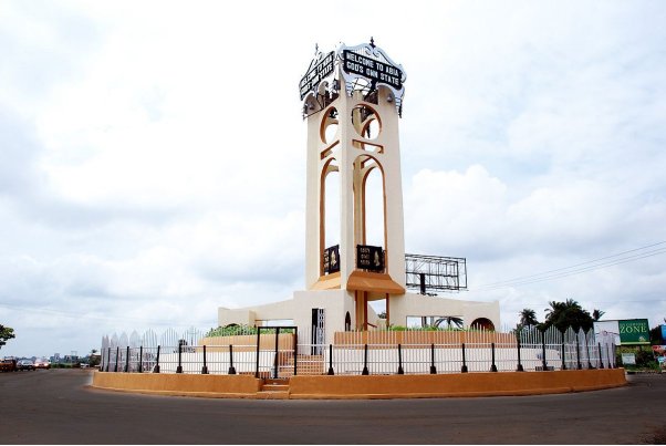
2. Abia State
Abia State was created in 1991 from the former Imo State and is often associated with the Niger Delta region. Geographically, Abia sits at a strategic intersection: it is both an Igbo heartland state and a state influenced by coastal and deltaic economic processes. This “borderland positioning” is important because Abia’s economy draws strength from manufacturing and trade while also benefiting from oil and gas activities that shape the wider south-south region.
The state covers an area of about 6,320 square kilometres and shares borders with Anambra, Enugu, and Ebonyi to the north, Imo to the west, Cross River and Akwa Ibom to the east, and Rivers to the south. These borders are not just lines; they are contact zones where goods, people, and ideas move daily. Abia’s proximity to Rivers State, for example, reinforces access to important transport routes and economic linkages that connect inland markets to coastal corridors.
The southern part of Abia is more riverine, with tropical rainforest conditions, while the remaining areas include higher plains that transition toward savanna-like vegetation in places. These environmental differences shape land use patterns: forest and riverine zones often support oil palm, fishing activities in certain locations, and wetter-soil crops, while drier zones support a mix of staple farming and settlement expansion.
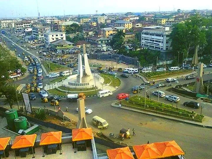
Abia’s population includes a strong Igbo majority and is often described as predominantly Christian. This matters culturally, but economically the state’s identity is heavily tied to Aba, the famous industrial and trading city that functions as Abia’s economic heartbeat. While Umuahia is the capital city and important administrative centre, Aba is the “market engine” where manufacturing, craftsmanship, and trade intensify.
Aba: Industrial Craft, Informal Manufacturing, and Trade Density
Aba is widely known for production: textiles, footwear, plastics, cement-linked products, pharmaceuticals, cosmetics, and a wide range of consumer goods. From a geographer’s viewpoint, Aba represents a classic African industrial city where formal and informal production systems coexist. Workshops, small factories, and artisan clusters form dense economic ecosystems. This is one reason Abia’s prosperity cannot be fully captured by official revenue alone: Aba’s informal economy can be enormous and may not be fully represented in formal tax systems, yet it sustains thousands of households.
Abia’s oil and gas sector also contributes significantly to state GDP (figures cited in various sources often mention substantial contributions). Resource sectors can raise revenue, but they also create volatility—since global commodity prices and production patterns can change quickly. The resilience of Abia’s economy therefore benefits from diversification: manufacturing and trade provide buffers when oil revenue fluctuates.
Agriculture remains important, employing a large share of the population. Crops such as yams, cassava, maize, plantains, and oil palm are significant. Oil palm is especially important because it supports both subsistence use and commercial value chains (oil, soap, food processing). In rural geography, agriculture also shapes migration: when urban income opportunities rise in Aba, rural youth may migrate toward the city; when agricultural value chains strengthen, rural economies can retain labor and reinvest in land.
The state has two major power-related projects frequently mentioned in discussions: the Alaoji Power Plant and the Geometric Power Plant, aimed at improving supply. Energy is crucial for industrial cities. When electricity is unreliable, manufacturers rely on generators, increasing production costs and reducing competitiveness. So, infrastructure and power are not side issues—they determine whether Aba’s industrial potential is fully realized.
Abia is also home to multiple universities: Michael Okpara University of Agriculture, Abia State University, Gregory University, and Rhema University. Education supports workforce development and professional service growth, and it can also stimulate local economies through student housing and retail demand.
Healthcare infrastructure includes major institutions such as the Federal Medical Center in Umuahia and Abia State University Teaching Hospital in Aba. Health geography matters because cities with stronger health institutions tend to attract more population stability and professional activity, and they reduce vulnerability during health crises.
Under the leadership of Governor Dr. Alex Otti, the state has recorded efforts aimed at improving infrastructure and governance, and many observers link governance reforms to investment confidence. Abia’s capital is Umuahia, but Aba remains the economic heartbeat of the state.
3. Imo State
Imo State is often considered one of the richer states in Igbo land, and its economic geography is shaped by a mix of resource endowment, urban services, and industrial activity. Created in 1976, it was carved out of the old East-Central State and is named after the Imo River, which flows through the region. River systems often become symbolic anchors for state identity, but they also influence settlement patterns, farmland moisture regimes, and transport routes.
The capital is Owerri, also the largest city in the state. Owerri functions as both a cultural centre and an economic hub, with a strong service economy—hospitality, education, retail, and administrative services. In many Nigerian states, the capital city becomes a concentration point for government employment and services, and Owerri fits that pattern while also functioning as a regional connector between neighboring states.
Imo covers about 5,100 square kilometres and shares borders with Anambra to the north, Abia to the east, and Rivers to the south and west. This border arrangement gives Imo access to multiple economic corridors, especially those linked to the oil-rich south-south region. Movement between Owerri and parts of Rivers and Abia supports commuter flows, trade routes, and supply chains.
As of 2022, Imo is often cited as having a population of over 5.4 million people and is among the more densely populated states in Nigeria. High population density creates strong consumer markets and labor supply, but also increases pressure on land, housing, and infrastructure. Population density can push economic activity upward if infrastructure supports it; it can also magnify social stress if infrastructure lags behind.
The people of Imo are mostly Igbo. English is the official language, while Igbo is spoken widely. But the economic story is strongly tied to natural resources and industrial presence. Imo is described as having over 163 oil wells, making crude oil one of its key resources. These oil wells are spread across local government areas such as Ohaji/Egbema and Oguta. Resource geography matters here: oil infrastructure shapes land use, labor migration, and political economy, and can also influence environmental risks such as spills and water pollution.
Besides oil, the state has deposits of natural gas, lead, and zinc. It also has fertile soils supporting agriculture—yams, cassava, and palm oil are commonly grown. Its forests include valuable timber species such as iroko and mahogany. These resources create an economic opportunity, but they also require sustainable governance. Timber extraction, for example, can degrade ecosystems if unmanaged, affecting long-term agricultural productivity and local microclimates.
Imo’s economy is described as diverse, with reports referencing over 2,000 factories producing goods such as pharmaceuticals and food products. Big companies, including Nigerian Breweries, have a presence in the state, supporting industrial growth and creating employment multipliers. In regional development geography, such firms also stimulate secondary industries—transport services, packaging supply, retail distribution, and maintenance trades.
Geographic significance: Imo demonstrates a classic mixed economy. Oil provides fiscal capacity, while Owerri’s service economy and manufacturing presence provide broader employment and market circulation. The state’s position adjoining Rivers and Abia strengthens connectivity, which supports trade and regional movement.
Comparing the Three States: What the Revenue Ranking Reflects
When we step back and compare Anambra, Abia, and Imo through a geographer’s lens, the revenue ranking begins to make sense as a reflection of different economic engines:
- Anambra (₦30.9 billion): Strong market centrality (Onitsha), industrial clustering (Nnewi), and dense urban commerce that continuously circulates goods and capital.
- Abia (₦21.5 billion): Manufacturing and craft production anchored by Aba, combined with trade density and contributions from oil and gas.
- Imo (₦18.2 billion): Resource endowment (oil wells) plus a service-heavy capital (Owerri) and industrial presence that diversifies the economy.
However, the ranking also highlights a governance challenge common in many regions: how effectively a state converts revenue into broad-based development. Roads, power supply, water systems, schools, healthcare access, and security conditions all affect whether prosperity is felt widely or concentrated in specific urban clusters. A geographer therefore treats revenue as an entry point—a useful signal, but not the full story.
Key Development Challenges That Can Shape “Richness” Over Time
Even the richest states face challenges that can erode prosperity if unmanaged. Across parts of south-eastern Nigeria, common issues include:
- Transport bottlenecks: congested corridors, road quality issues, and heavy truck traffic affecting trade efficiency.
- Power supply instability: affecting manufacturing competitiveness and household productivity.
- Urban pressure: high density creates stress on housing, sanitation, and mobility.
- Environmental risks: flooding, erosion, and pollution (especially in oil-linked zones).
- Security and confidence: investment responds quickly to perceived risk.
Where these challenges are addressed effectively—through infrastructure, planning, and transparent governance—economic activity tends to expand. Where they persist, businesses adapt (often through informal coping systems) but long-term growth is constrained. This is why “richest state” lists should always be read alongside development strategies and quality-of-life indicators.
Conclusion
This guide ranked the top three richest states in Igbo land as listed here using approximate annual revenue: Anambra (₦30.9 billion), Abia (₦21.5 billion), and Imo (₦18.2 billion). Beyond the figures, the deeper geographic story is that each state’s prosperity is anchored in distinct economic landscapes: Anambra’s market and industrial corridor, Abia’s manufacturing and trade ecosystem centered on Aba, and Imo’s combination of resource endowment and urban service economy.
From an expert geographer’s viewpoint, these states illustrate a broader truth about the south-east: wealth is produced through networks—of markets, roads, apprenticeships, industries, and diaspora ties. Revenue is an important indicator, but sustained prosperity depends on how effectively states manage infrastructure, environmental risks, and the everyday conditions that allow people and goods to move.
If you are using this guide for research or comparison, treat the ranking as a structured overview—not the final word. The most meaningful measure of “richness” is how economic energy is translated into improved livelihoods, better services, and resilience for households across both urban and rural communities.